
The Yellow Path
OK... it's underwater.

There’s a favourite swim which I do about two, maybe 3 times a year. I do it in the morning when the lake is quiet rather than the afternoon when it's busier with boaties and waterskiers. Because when doing this swim route you end up right out in the middle of Roys Bay.
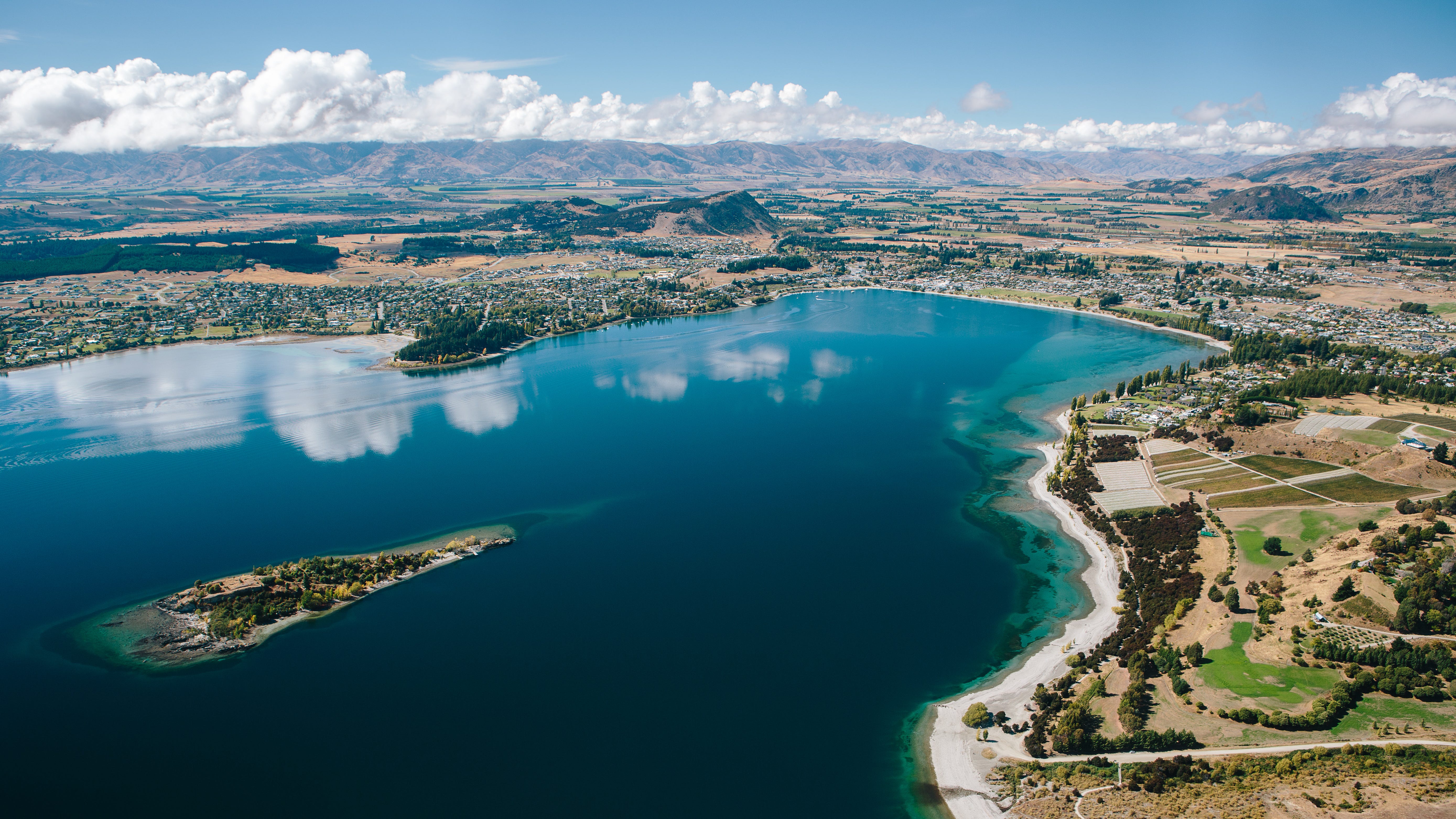
I ‘discovered’ the route maybe 5 or 6 years ago, but to be honest I can no longer remember if I found it myself, superimposing into my mind's eye, whilst swimming, from the image (see the header image) we use on the website of the Ruby Island Swim or someone else showed me, I know not who. Or it was a hive mind adventure one morning. But whatever…
As the season gets under way, the Sunday morning swims with the club get a little longer each week. We go out to ‘the rock’ about a 1km straight line from the watersports clubhouse building at Stoney Creek.
Out we go, past the first westerly red marker buoy of the swimmers buoy line on our right. Shortly afterwards we pass the famous #thatwanakatree on our distant left with the teeming hordes of tourists taking Instagram and Facebook pictures for ‘I’ve made it to here’ posting. This is always a point of debate among many of us on an entirely different tangent to this particular story - why do people come JUST to take a picture of the tree and then leave? And they clog the car park goddammit! Literally a thousand people a day get ‘that’ shot. Let’s cut the poor innocent tree down, some say… but as I said, I digress.
Sometimes, between the shore and the first red witches hat (as we call those red marker buoys), we may swim over an eel. And they can be big, and they can catch you by surprise, a moving shadow on the lake floor, off the periphery of vision. Shock! It garners a certain primitive revulsion, like hating snakes or spiders. But after you’ve seen a few of them and the shock of the shock no longer shocks, you notice how serenely they move through the watery matrix. They certainly have no concern for you swimming above them.
Up, and onwards up the line of yellow five knot marker buoys we go. These yellow buoys positioned 200m off shore, mark the extent within which powered watercraft must keep their speed down to 5 knots. Hence the swimmers have a good space to feel comparatively safe, notwithstanding the odd wayward rowing skiff coming at you at times, because they can’t see you as all the rowers face backwards. i.e. they are not looking where they are going! Someone should invent a mechanical mechanism for these boats whereby they can face forwards but still make all the movements of rowing backwards. That's a million dollar idea right there (but probably been done already and found to be rubbish).
Up and further up the yellow 5 knot line we go, pulling left in the last 300m over the tumbled and discarded underwater rock field that signals you are not so very far away from ‘the rock’. A destination in its very own right. “How far did you swim today” “Me? Oh I swam to The Rock”, such is its stature of boastful accomplishment.
And from here, after either de-rigueur touching or swimming around the rock (preferably both), you swim back to the club house, usually hugging the shore line a little closer, because of which you are more obvious to walking passers-by on the lake-side track, making them a little envious I’m sure. You can feel it.
But alternatively, rather than swimming back ‘as standard’ from the rock, from this point is where the Yellow Path (or the Yellow Edge, or the yellow brick (underwater) road) begins. It’s course is the edge of the shallow shelf you see at the top right of the header image.
From ‘The Rock’ swim out towards the middle of the lake towards the Yacht Club's large orange turn buoy No. 2. It's about 150 meters to the buoy. As you start swimming out you are still over the perfectly visible lake floor, even though it is perhaps 12 to 15 meters below, swimming over the smooth sandy rippled lake bed. Perhaps 2/3rds of the way to the buoy you swim over the drop off, where the shallow becomes the deep. It's tempting to simply turn right at this point and follow the drop off, but the draw of buoy No.2 is strong. Like The Force. Plus it's a few meters more on the weekly Strava goal!
Anyway, after the buoy has been snagged, a diagonal route west, back towards land soon brings you once again to the juncture of the ‘drop off’, but now from the other direction, and thus The Yellow Edge.
You divert left-wards and swim along the rounded contour between the flat shallower rippled lake bed to your right and the greeny blue darkness of the deep lake to your left. The Drop Off.
Navigating along this edge is very entertaining. There’s a lot going on, actually. Non swimmers may not get this, like, how can there be anything at all going on whilst swimming. But that would be to belittle the experience. OK, it's more subtle, the experience is not streaming at you at speed like driving a car around your favourite winding road section or slamming down a hill on your bike. It’s not exhilarating in that manner, but nonetheless you are captivated as you swim along the apex of the rounded transition between shallow and deep.
Soon enough, you encounter a yellow or ochre tinged, for what you would naturally want to call - ‘moss’. Underwater yellow coloured moss. That's how I see it and understand it. Moss. And to be honest, it's easy to not notice. Easy to dismiss. To not realise it is, in fact, a unique underwater natural phenomenon. It exists only along the top edge of the domed boundary, on the ‘shallow’ side of the drop off. It’s not on the steeper sloping side that drops into the deep. The ‘moss’ peters out the further it moves into the shallow plateau. It only exists on the very edge between deep and shallow. It demarcates the boundary. A zone of its own. It’s a veritable underwater yellow trail to follow along. You are now Dorothy in The Wizard of Oz. Where will it lead? What will you find?
As you swim along this yellow edge, you will note the yellow comes and goes. The ‘moss’ leaves, then it reappears in your underwater distance. You simply need to follow. Follow the yellow brick road to good things. You are on the lookout for small things, you may see a trout, you will see freshwater mussels, their white/brown ridged line looking like scattered quartz pebbles, thinking what are those rocks doing here, but realising in the same instant it’s not a rock but a living moving mussel. You will see the faint tracks they leave in the sand on the shallow left side. Tracks you didn’t see before, but now you are looking for small things, things you wouldn't normally see but now you do. And that's what you do all the way along the line. You see things you would not normally see or would just dismiss. Sunken branches. Light reflections. And you are route finding. And you are looking at the above water horizon as you breathe, the jaggy mountains, the green, the Central Otago brown, the blue sky, perhaps there's still snow on the tops. And you are counting breaths. You are moving forward. You are doing it all.
The yellow line is not straight, it winds to the left and pushes to the right, taking you at times further into the middle of the lake and further into no man's land and away from the safety of the shore. But at the same time you know you simply need to keep following along the rusty trajectory ahead and to its eventual end, as it culminates blending into the southern shore line at a section where the underwater Lagarosiphon weed has become prolific. There is a tendency here to hang right following the more pronounced line of weed, a mental draw of a shorter route to and along the east-west swimmers buoy line, now becoming visible on your right side breath and back to your start point, but no, you must resist this urge and keep your swim adventure boldness to the fore, and hang left. Persevere. Some subtle route finding is required to glean the true line of the drop off as it now tends in a more easterly direction, finally sweeping a big radius as the lakefront takes precedence. By now you are approaching one of the southern lake edge yellow buoys and thus you are within 200m meters of the shore. A feeling of safe ground washes over. “Phew! I’m safe”. From here you swim the swimmers buoy line back to the Watersports Centre - your start point, or perhaps swim straight on to the ‘new carpark’ a possible alternate start/finish terminus.
The full circuit is about 3.2km which is a comparatively long’ish swim, but the beauty is you really don’t notice the distance. It's so entertaining. You are not on a time frame here, it's not about speeding through. You are a swim tourist, taking in the sights above and below. Enjoying the journey.
You may desire a safety tow buoy, but at the least, just make sure you have clear goggles, otherwise you’ll see nothing …
I like the yellow path. Must go do again soon!!
Great read!! 🌟🌟🌟